
| Free Flag Facts | ||
| Cilck here - Animated
Flag Large Static Flag |
Nauru |

|
|
| Introduction | Nauru |
|
Background:
|
Nauru's phosphate deposits began to be mined early in the 20th century by a German-British consortium; the island was occupied by Australian forces in World War I. Nauru achieved independence in 1968 and joined the UN in 1999. Nauru is the world's smallest independent republic. |
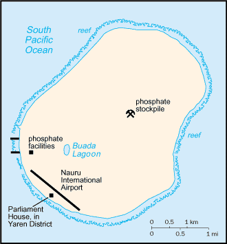
| Geography | Nauru |
|
Location:
|
Oceania, island in the South Pacific Ocean, south of the Marshall Islands |
|
Geographic coordinates:
|
0 32 S, 166 55 E |
|
Map references:
|
Oceania |
|
Area:
|
total: 21 sq km
water: 0 sq km land: 21 sq km |
|
Area - comparative:
|
about 0.1 times the size of Washington, DC |
|
Land boundaries:
|
0 km |
|
Coastline:
|
30 km |
|
Maritime claims:
|
contiguous zone: 24 NM
territorial sea: 12 NM exclusive economic zone: 200 NM |
|
Climate:
|
tropical; monsoonal; rainy season (November to February) |
|
Terrain:
|
sandy beach rises to fertile ring around raised coral reefs with phosphate plateau in center |
|
Elevation extremes:
|
lowest point: Pacific Ocean 0 m
highest point: unnamed location along plateau rim 61 m |
|
Natural resources:
|
phosphates, fish |
|
Land use:
|
arable land: 0%
permanent crops: 0% other: 100% (1998 est.) |
|
Irrigated land:
|
NA sq km |
|
Natural hazards:
|
periodic droughts |
|
Environment - current issues:
|
limited natural fresh water resources, roof storage tanks collect rainwater, but mostly dependent on a single, aging desalination plant; intensive phosphate mining during the past 90 years - mainly by a UK, Australia, and NZ consortium - has left the central 90% of Nauru a wasteland and threatens limited remaining land resources |
|
Environment - international agreements:
|
party to: Biodiversity, Climate Change, Climate Change-Kyoto Protocol, Desertification, Hazardous Wastes, Law of the Sea, Marine Dumping, Ozone Layer Protection
signed, but not ratified: none of the selected agreements |
|
Geography - note:
|
Nauru is one of the three great phosphate rock islands in the Pacific Ocean - the others are Banaba (Ocean Island) in Kiribati and Makatea in French Polynesia; only 53 km south of Equator |
| People | Nauru |
|
Population:
|
12,570 (July 2003 est.) |
|
Age structure:
|
0-14 years: 38.9% (male 2,517; female 2,368)
15-64 years: 59.3% (male 3,681; female 3,779) 65 years and over: 1.8% (male 116; female 109) (2003 est.) |
|
Median age:
|
total: 19.6 years
male: 19.3 years female: 20 years (2002) |
|
Population growth rate:
|
1.9% (2003 est.) |
|
Birth rate:
|
26.09 births/1,000 population (2003 est.) |
|
Death rate:
|
7.08 deaths/1,000 population (2003 est.) |
|
Net migration rate:
|
0 migrant(s)/1,000 population (2003 est.) |
|
Sex ratio:
|
at birth: 1.05 male(s)/female
under 15 years: 1.06 male(s)/female 15-64 years: 0.97 male(s)/female 65 years and over: 1.06 male(s)/female total population: 1.01 male(s)/female (2003 est.) |
|
Infant mortality rate:
|
total: 10.33 deaths/1,000 live births
female: 7.52 deaths/1,000 live births (2003 est.) male: 13 deaths/1,000 live births |
|
Life expectancy at birth:
|
total population: 61.95 years
male: 58.41 years female: 65.66 years (2003 est.) |
|
Total fertility rate:
|
3.4 children born/woman (2003 est.) |
|
HIV/AIDS - adult prevalence rate:
|
NA% |
|
HIV/AIDS - people living with HIV/AIDS:
|
NA |
|
HIV/AIDS - deaths:
|
NA |
|
Nationality:
|
noun: Nauruan(s)
adjective: Nauruan |
|
Ethnic groups:
|
Nauruan 58%, other Pacific Islander 26%, Chinese 8%, European 8% |
|
Religions:
|
Christian (two-thirds Protestant, one-third Roman Catholic) |
|
Languages:
|
Nauruan (official, a distinct Pacific Island language), English widely understood, spoken, and used for most government and commercial purposes |
|
Literacy:
|
definition: NA
total population: NA% male: NA% female: NA% |
| Government | Nauru |
|
Country name:
|
conventional long form: Republic of Nauru
conventional short form: Nauru former: Pleasant Island |
|
Government type:
|
republic |
|
Capital:
|
no official capital; government offices in Yaren District |
|
Administrative divisions:
|
14 districts; Aiwo, Anabar, Anetan, Anibare, Baiti, Boe, Buada, Denigomodu, Ewa, Ijuw, Meneng, Nibok, Uaboe, Yaren |
|
Independence:
|
31 January 1968 (from the Australia-, NZ-, and UK-administered UN trusteeship) |
|
National holiday:
|
Independence Day, 31 January (1968) |
|
Constitution:
|
29 January 1968 |
|
Legal system:
|
acts of the Nauru Parliament and British common law |
|
Suffrage:
|
20 years of age; universal and compulsory |
|
Executive branch:
|
chief of state: President Rene HARRIS (since 8 August 2003) note - the president is both the chief of state and head of government
elections: president elected by Parliament for a three-year term; election last held 29 May 2003 (next to be held NA 2006) note: Ludwig SCOTTY was removed from the presidency in a no-confidence vote 8 August 2003; Rene HARRIS became president election results: Ludwig SCOTTY elected president 29 May 2003; Ludwig SCOTTY 10 parliamentary votes, Kinza CLODUMAR 7 cabinet: Cabinet appointed by the president from among the members of Parliament head of government: President Rene HARRIS (since 8 August 2003) note - the president is both the chief of state and head of government |
|
Legislative branch:
|
unicameral Parliament (18 seats; members elected by popular vote to serve three-year terms)
elections: last held 3 May 2003 (next to be held not later than May 2006) election results: percent of vote - NA%; seats - Nauru First Party 3, independents 15 |
|
Judicial branch:
|
Supreme Court |
|
Political parties and leaders:
|
loose multiparty system; Democratic Party [Kennan ADEANG]; Nauru Party (informal) [leader NA]; Naoero Amo (Nauru First) Party [leader NA] |
|
Political pressure groups and leaders:
|
NA |
|
International organization participation:
|
ACP, AsDB, C, ESCAP, FAO, ICAO, ICCt, Interpol, IOC, ITU, OPCW, Sparteca, SPC, SPF, UN, UNESCO, UPU, WHO |
|
Diplomatic representation in the US:
|
Nauru does not have an embassy in the US, but does have a UN office at 800 2nd Avenue, Suite 400 D, New York, New York 10017; telephone: (212) 937-0074
consulate(s): Hagatna (Guam) |
|
Diplomatic representation from the US:
|
the US does not have an embassy in Nauru; the US Ambassador to Fiji is accredited to Nauru |
|
Flag description:
|
blue with a narrow, horizontal, yellow stripe across the center and a large white 12-pointed star below the stripe on the hoist side; the star indicates the country's location in relation to the Equator (the yellow stripe) and the 12 points symbolize the 12 original tribes of Nauru |
| Economy | Nauru |
|
Economy - overview:
|
Revenues of this tiny island have come from exports of phosphates, but reserves are expected to be exhausted within a few years. Phosphate production has declined since 1989, as demand has fallen in traditional markets and as the marginal cost of extracting the remaining phosphate increases, making it less internationally competitive. While phosphates have given Nauruans one of the highest per capita incomes in the Third World, few other resources exist with most necessities being imported, including fresh water from Australia. The rehabilitation of mined land and the replacement of income from phosphates are serious long-term problems. In anticipation of the exhaustion of Nauru's phosphate deposits, substantial amounts of phosphate income have been invested in trust funds to help cushion the transition and provide for Nauru's economic future. The government has been borrowing heavily from the trusts to finance fiscal deficits. To cut costs the government has called for a freeze on wages, a reduction of over-staffed public service departments, privatization of numerous government agencies, and closure of some overseas consulates. In recent years Nauru has encouraged the registration of offshore banks and corporations. Tens of billions of dollars have been channeled through their accounts. Few comprehensive statistics on the Nauru economy exist, with estimates of Nauru's GDP varying widely. |
|
GDP:
|
purchasing power parity - $60 million (2001 est.) |
|
GDP - real growth rate:
|
NA% |
|
GDP - per capita:
|
purchasing power parity - $5,000 (2001 est.) |
|
GDP - composition by sector:
|
agriculture: NA%
industry: NA% services: NA% |
|
Population below poverty line:
|
NA% |
|
Household income or consumption by percentage share:
|
lowest 10%: NA%
highest 10%: NA% |
|
Inflation rate (consumer prices):
|
-3.6% (1993) |
|
Labor force - by occupation:
|
employed in mining phosphates, public administration, education, and transportation |
|
Unemployment rate:
|
0% |
|
Budget:
|
revenues: $23.4 million
expenditures: $64.8 million, including capital expenditures of $NA (FY 95/96) |
|
Industries:
|
phosphate mining, offshore banking, coconut products |
|
Industrial production growth rate:
|
NA% |
|
Electricity - production:
|
30 million kWh (2001) |
|
Electricity - production by source:
|
fossil fuel: 100%
hydro: 0% other: 0% (2001) nuclear: 0% |
|
Electricity - consumption:
|
27.9 million kWh (2001) |
|
Electricity - exports:
|
0 kWh (2001) |
|
Electricity - imports:
|
0 kWh (2001) |
|
Oil - production:
|
0 bbl/day (2001 est.) |
|
Oil - consumption:
|
1,000 bbl/day (2001 est.) |
|
Oil - exports:
|
NA (2001) |
|
Oil - imports:
|
NA (2001) |
|
Agriculture - products:
|
coconuts |
|
Exports:
|
$27 million f.o.b. (1995) |
|
Exports - commodities:
|
phosphates |
|
Exports - partners:
|
India 46.1%, South Korea 18.3%, Australia 10.6%, New Zealand 7.8%, Netherlands 5.6% (2002) |
|
Imports:
|
$33 million c.i.f. (1995) |
|
Imports - commodities:
|
food, fuel, manufactures, building materials, machinery |
|
Imports - partners:
|
Australia 59.3%, US 10.1%, Ireland 7.6%, Malaysia 6% (2002) |
|
Debt - external:
|
$33.3 million |
|
Economic aid - recipient:
|
$2.25 million from Australia (FY96/97 est.) |
|
Currency:
|
Australian dollar (AUD) |
|
Currency code:
|
AUD |
|
Exchange rates:
|
Australian dollars per US dollar - 1.2641 (2002) 1.9320 (2001), 1.7173 (2000), 1.5497 (1999), 1.5888 (1998) |
|
Fiscal year:
|
1 July - 30 June |
| Communications | Nauru |
|
Telephones - main lines in use:
|
2,000 (1996) |
|
Telephones - mobile cellular:
|
450 (1994) |
|
Telephone system:
|
general assessment: adequate local and international radiotelephone communication provided via Australian facilities
domestic: NA international: satellite earth station - 1 Intelsat (Pacific Ocean) |
|
Radio broadcast stations:
|
AM 1, FM 0, shortwave 0 (1998) |
|
Radios:
|
7,000 (1997) |
|
Television broadcast stations:
|
1 (1997) |
|
Televisions:
|
500 (1997) |
|
Internet country code:
|
.nr |
|
Internet Service Providers (ISPs):
|
1 (2000) |
|
Internet users:
|
NA |
| Transportation | Nauru |
|
Railways:
|
total: 5 km
note: gauge unknown; used to haul phosphates from the center of the island to processing facilities on the southwest coast (2001) |
|
Highways:
|
total: 30 km
paved: 24 km unpaved: 6 km (1999 est.) |
|
Waterways:
|
none |
|
Ports and harbors:
|
Nauru |
|
Merchant marine:
|
none (2002 est.) |
|
Airports:
|
1 (2002) |
|
Airports - with paved runways:
|
total: 1
1,524 to 2,437 m: 1 (2002) |
| Military | Nauru |
|
Military branches:
|
no regular military forces; Nauru Police Force |
|
Military manpower - availability:
|
males age 15-49: 3,190 (2003 est.) |
|
Military manpower - fit for military service:
|
males age 15-49: 1,762 (2003 est.) |
|
Military expenditures - dollar figure:
|
$NA |
|
Military expenditures - percent of GDP:
|
NA% |
|
Military - note:
|
Nauru maintains no defense forces; under an informal agreement, defense is the responsibility of Australia |
| Transnational Issues | Nauru |
|
Disputes - international:
|
none |
|
Illicit drugs:
|
broad-based money-laundering center |