
| Free Flag Facts | ||
| Cilck here - Animated
Flag Large Static Flag |
East Timor |

|
|
| Introduction | East Timor |
|
Background:
|
The Portuguese colony of Timor declared itself independent from Portugal on 28 November 1975 and was invaded and occupied by Indonesian forces nine days later. It was incorporated into Indonesia in July 1976 as the province of East Timor. A campaign of pacification followed over the next two decades, during which an estimated 100,000 to 250,000 individuals lost their lives. On 30 August 1999, in a UN-supervised popular referendum, the people of East Timor voted for independence from Indonesia. During 1999-2001, pro-integrationist militias - supported by Indonesia - conducted indiscriminate violence. On 20 May 2002, East Timor was internationally recognized as an independent state and the world's newest democracy. |
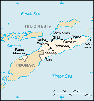
| Geography | East Timor |
|
Location:
|
Southeastern Asia, northwest of Australia in the Lesser Sunda Islands at the eastern end of the Indonesian archipelago; note - East Timor includes the eastern half of the island of Timor, the Oecussi (Ambeno) region on the northwest portion of the island of Timor, and the islands of Pulau Atauro and Pulau Jaco |
|
Geographic coordinates:
|
8 50 S, 125 55 E |
|
Map references:
|
Southeast Asia |
|
Area:
|
total: 15,007 sq km
land: NA sq km water: NA sq km |
|
Area - comparative:
|
slightly larger than Connecticut |
|
Land boundaries:
|
total: 228 km
border countries: Indonesia 228 km |
|
Coastline:
|
706 km |
|
Maritime claims:
|
contiguous zone: NA NM
extended fishing zone: NA NM territorial sea: NA NM exclusive fishing zone: NA NM continental shelf: NA NM exclusive economic zone: NA NM |
|
Climate:
|
tropical; hot, humid; distinct rainy and dry seasons |
|
Terrain:
|
mountainous |
|
Elevation extremes:
|
lowest point: Timor Sea, Savu Sea, and Banda Sea 0 m
highest point: Foho Tatamailau 2,963 m |
|
Natural resources:
|
gold, petroleum, natural gas, manganese, marble |
|
Land use:
|
arable land: NA%
other: NA% permanent crops: NA% |
|
Irrigated land:
|
1,065 sq km (est.) |
|
Natural hazards:
|
floods and landslides are common; earthquakes, tsunamis, tropical cyclones |
|
Environment - current issues:
|
widespread use of slash and burn agriculture has led to deforestation and soil erosion |
|
Environment - international agreements:
|
NA |
|
Geography - note:
|
Timor comes from the Malay word for "Orient;" the island of Timor is part of the Malay Archipelago and is the largest and easternmost of the Lesser Sunda Islands |
| People | East Timor |
|
Population:
|
997,853
note: other estimates range as low as 800,000 (2002 est.) (July 2003 est.) |
|
Age structure:
|
NA (2003 est.) |
|
Median age:
|
total: 19.7 years
female: 19.6 years (2002) male: 19.8 years |
|
Population growth rate:
|
2.13% (2003 est.) |
|
Birth rate:
|
27.75 births/1,000 population (2003 est.) |
|
Death rate:
|
6.41 deaths/1,000 population (2003 est.) |
|
Net migration rate:
|
0 migrant(s)/1,000 population (2003 est.) |
|
Sex ratio:
|
at birth: 1.05 male(s)/female
under 15 years: 1.03 male(s)/female 15-64 years: 1.04 male(s)/female 65 years and over: 0.97 male(s)/female total population: 1.04 male(s)/female (2003 est.) |
|
Infant mortality rate:
|
total: 50.47 deaths/1,000 live births
female: 43.55 deaths/1,000 live births (2003 est.) male: 57.05 deaths/1,000 live births |
|
Life expectancy at birth:
|
total population: 65.2 years
female: 67.55 years (2003 est.) male: 62.97 years |
|
Total fertility rate:
|
3.79 children born/woman (2003 est.) |
|
HIV/AIDS - adult prevalence rate:
|
NA% |
|
HIV/AIDS - people living with HIV/AIDS:
|
NA |
|
HIV/AIDS - deaths:
|
NA |
|
Nationality:
|
noun: Timorese
adjective: Timorese |
|
Ethnic groups:
|
Austronesian (Malayo-Polynesian), Papuan, small Chinese minority |
|
Religions:
|
Roman Catholic 90%, Muslim 4%, Protestant 3%, Hindu 0.5%, Buddhist, Animist (1992 est.) |
|
Languages:
|
Tetum (official), Portuguese (official), Indonesian, English
note: there are about 16 indigenous languages; Tetum, Galole, Mambae, and Kemak are spoken by significant numbers of people |
|
Literacy:
|
definition: age 15 and over can read and write
total population: 48% (2001) male: NA% female: NA% |
| Government | East Timor |
|
Country name:
|
conventional long form: Democratic Republic of Timor-Leste
conventional short form: East Timor local short form: Timor Lorosa'e [Tetum]; Timor-Leste [Portuguese] former: Portuguese Timor local long form: Republika Demokratika Timor Lorosa'e [Tetum]; Republica Democratica de Timor-Leste [Portuguese] |
|
Government type:
|
republic |
|
Capital:
|
Dili |
|
Administrative divisions:
|
13 administrative districts; Aileu, Ainaro, Baucau, Bobonaro (Maliana), Cova-Lima (Suai), Dili, Ermera, Lautem (Los Palos), Liquica, Manatuto, Manufahi (Same), Oecussi (Ambeno), Viqueque |
|
Independence:
|
28 November 1975 (date of proclamation of independence from Portugal); note - 20 May 2002 is the official date of international recognition of East Timor's independence from Indonesia |
|
National holiday:
|
Independence Day, 28 November (1975) |
|
Constitution:
|
22 March 2002 (based on the Portuguese model) |
|
Legal system:
|
UN-drafted legal system based on Indonesian law (2002) |
|
Suffrage:
|
17 years of age; universal |
|
Executive branch:
|
chief of state: President Jose Alexander GUSMAO (since 20 May 2002); note - the president plays a largely symbolic role but is able to veto some legislation; he often is referred to as Xanana GUSMAO
head of government: Prime Minister Mari Bin Amude ALKATIRI (since 20 May 2002) cabinet: Council of State elections: president elected by popular vote for a five-year term; election last held 14 April 2002 (next to be held NA April 2007); after the first legislative elections, the leader of the majority party was appointed prime minister by the president, suggesting a precedent for the future election results: Jose Alexander GUSMAO elected president; percent of vote - Jose Alexander GUSMAO 82.7%, Francisco Xavier do AMARAL 17.3% |
|
Legislative branch:
|
unicameral National Parliament (number of seats can vary, minimum requirement of 52 and a maximum of 65 seats; members elected by popular vote to serve five-year terms); note - for its first term of office, the National Parliament is comprised of 88 members on an exceptional basis
elections: last held 30 August 2001 (next to be held NA August 2006) election results: percent of vote by party - FRETILIN 57.37%, PD 8.72%, PSD 8.18%, ASDT 7.84%, UDT 2.36%, PNT 2.21%, KOTA 2.13%, PPT 2.01%, PDC 1.98%, PST 1.78%, independents/other 5.42%; seats by party - FRETILIN 55, PD 7, PSD 6, ASDT 6, PDC 2, UDT 2, KOTA 2, PNT 2, PPT 2, UDC/PDC 1, PST 1, PL 1, independent 1 |
|
Judicial branch:
|
Supreme Court of Justice, one judge appointed by the National Parliament and the rest appointed by the Superior Council for the Judiciary |
|
Political parties and leaders:
|
Associacao Social-Democrata Timorense or ASDT [Francisco Xavier do AMARAL]; Christian Democratic Party of Timor or PDC [Antonio XIMENES]; Christian Democratic Union of Timor or UDC [Vicente da Silva GUTERRES]; Democratic Party or PD [Fernando de ARAUJO]; Liberal Party or PL [leader NA]; Maubere Democratic Party or PDM [leader NA]; People's Party of Timor or PPT [Jacob XAVIER]; Revolutionary Front of Independent East Timor or FRETILIN [Lu OLO]; Social Democrat Party of East Timor or PSD [Mario CARRASCALAO]; Socialist Party of Timor or PST [leader NA]; Sons of the Mountain Warriors (also known as Association of Timorese Heroes) or KOTA [Clementino dos Reis AMARAL]; Timor Democratic Union or UDT [Joao CARRASCALAO]; Timor Labor Party or PTT [Paulo Freitas DA SILVA]; Timorese Nationalist Party or PNT [Abilio ARAUJO]; Timorese Popular Democratic Association or APODETI [Frederico Almeida-Santos DA COSTA] |
|
Political pressure groups and leaders:
|
NA |
|
International organization participation:
|
AsDB, IBRD, ICCt, IDA, IMF, Interpol, UN, WHO |
|
Diplomatic representation in the US:
|
chief of mission: Ambassador Jose Luis GUTERRES
consulate(s) general: New York (the ambassador resides in New York) (2003) FAX: 202 965-1517 telephone: 202 965-1515 chancery: 3415 Massachusetts Avenue, Washington, DC 20007 |
|
Diplomatic representation from the US:
|
chief of mission: Ambassador Grover Joseph REES
embassy: Vila 10, Avenida de Portugal, Farol, Dili mailing address: Department of State, 8250 Dili Place, Washington, DC 20521-8250 telephone: (670) 332-4684, 331-3205/3160/3472 FAX: (670) 331-3206 |
|
Flag description:
|
red, with a black isosceles triangle (based on the hoist side) superimposed on a slightly longer yellow arrowhead that extends to the center of the flag; there is a white star in the center of the black triangle |
| Economy | East Timor |
|
Economy - overview:
|
In late 1999, about 70% of the economic infrastructure of East Timor was laid waste by Indonesian troops and anti-independence militias, and 260,000 people fled westward. Over the next three years, however, a massive international program, manned by 5,000 peacekeepers (8,000 at peak) and 1,300 police officers, led to substantial reconstruction in both urban and rural areas. By mid-2002, all but about 50,000 of the refugees had returned. The country faces great challenges in continuing the rebuilding of infrastructure and the strengthening of the infant civil administration. One promising long-term project is the planned development of oil resources in nearby waters. |
|
GDP:
|
purchasing power parity - $440 million (2001 est.) |
|
GDP - real growth rate:
|
18% (2001 est.) |
|
GDP - per capita:
|
purchasing power parity - $500 (2001 est.) |
|
GDP - composition by sector:
|
agriculture: 25.4%
industry: 17.2% services: 57.4% (2001) |
|
Population below poverty line:
|
42% (2002 est.) |
|
Household income or consumption by percentage share:
|
lowest 10%: NA%
highest 10%: NA% |
|
Distribution of family income - Gini index:
|
38 (2002 est.) |
|
Inflation rate (consumer prices):
|
NA% |
|
Labor force:
|
NA |
|
Labor force - by occupation:
|
NA |
|
Unemployment rate:
|
50% (including underemployment) |
|
Budget:
|
revenues: $36 million
expenditures: $97 million, including capital expenditures of $NA (2003 est.) |
|
Industries:
|
printing, soap manufacturing, handicrafts, woven cloth |
|
Industrial production growth rate:
|
8.5% |
|
Electricity - production:
|
NA kWh (2001) |
|
Electricity - production by source:
|
fossil fuel: 100%
hydro: 0% other: 0% (2001) nuclear: 0% |
|
Electricity - consumption:
|
NA kWh (2001) |
|
Electricity - exports:
|
0 kWh (2001) |
|
Electricity - imports:
|
0 kWh (2001) |
|
Agriculture - products:
|
coffee, rice, maize, cassava, sweet potatoes, soybeans, cabbage, mangoes, bananas, vanilla |
|
Exports:
|
$8 million (2001 est.) |
|
Exports - commodities:
|
coffee, sandalwood, marble; note - the potential for oil and vanilla exports |
|
Exports - partners:
|
NA |
|
Imports:
|
$237 million (2001 est.) |
|
Imports - commodities:
|
mainly food (2001) |
|
Imports - partners:
|
NA |
|
Debt - external:
|
$NA |
|
Economic aid - recipient:
|
$2.2 billion (1999-2002 est.) |
|
Currency:
|
US dollar (USD) |
|
Currency code:
|
IDR |
|
Exchange rates:
|
see US dollar |
|
Fiscal year:
|
1 July - 30 June |
| Communications | East Timor |
|
Telephones - main lines in use:
|
NA |
|
Telephones - mobile cellular:
|
NA |
|
Telephone system:
|
NA |
|
Radio broadcast stations:
|
AM NA, FM NA, shortwave NA |
|
Radios:
|
NA |
|
Television broadcast stations:
|
NA |
|
Televisions:
|
NA |
|
Internet country code:
|
.tp |
|
Internet Service Providers (ISPs):
|
NA |
|
Internet users:
|
NA |
| Transportation | East Timor |
|
Railways:
|
0 km |
|
Highways:
|
total: 3,800 km
paved: 428 km unpaved: 3,372 km (1995) |
|
Waterways:
|
NA |
|
Pipelines:
|
NA |
|
Ports and harbors:
|
NA |
|
Merchant marine:
|
total: NA
ships by type: NA |
|
Airports:
|
8 (2002) |
|
Airports - with paved runways:
|
total: 3
2,438 to 3,047 m: 1 1,524 to 2,427 m: 1 914 to 1,523 m: 1 (2002) |
|
Airports - with unpaved runways:
|
total: 5
914 to 1,523 m: 3 under 914 m: 2 (2002) |
|
Heliports:
|
1 (2002) |
| Military | East Timor |
|
Military branches:
|
The East Timor Defense Force or FALINTIL-FDTL comprises a light-infantry Army and a small Naval component; note - plans are to develop a force of 1,500 active personnel and 1,500 reserve personnel over the next five years |
|
Military manpower - military age:
|
18-21 years of age (2003 est.) |
|
Military manpower - availability:
|
NA |
|
Military manpower - fit for military service:
|
NA |
|
Military manpower - reaching military age annually:
|
NA |
|
Military expenditures - dollar figure:
|
$4.4 million (FY03) |
|
Military expenditures - percent of GDP:
|
NA% |
| Transnational Issues | East Timor |
|
Disputes - international:
|
East Timor-Indonesia Boundary Committee meets regularly to survey and delimit the land boundary; some East Timor refugees delay return from camps in Indonesia; maritime delimitation and resource-sharing agreements signed with Australia resolved dispute over "Timor Gap" hydrocarbon reserves, but maritime agreement with Indonesia awaits further discussions |
|
Illicit drugs:
|
NA |