
| Free Flag Facts | ||
| Cilck here - Animated
Flag Large Static Flag |
Navassa Island |
|
|
| Introduction | Navassa Island |
|
Background:
|
This uninhabited island was claimed by the US in 1857 for its guano, and mining took place between 1865 and 1898. The lighthouse, built in 1917, was shut down in 1996 and administration of Navassa Island transferred from the Coast Guard to the Department of the Interior. A 1998 scientific expedition to the island described it as a unique preserve of Caribbean biodiversity; the following year it became a National Wildlife Refuge. |
| Geography | Navassa Island |
|
Location:
|
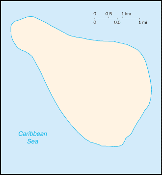
Caribbean, island in the Caribbean Sea, about one-fourth of the way from Haiti to Jamaica |
|
Geographic coordinates:
|
18 25 N, 75 02 W |
|
Map references:
|
Central America and the Caribbean |
|
Area:
|
total: 5.2 sq km
water: 0 sq km land: 5.2 sq km |
|
Area - comparative:
|
about nine times the size of The Mall in Washington, DC |
|
Land boundaries:
|
0 km |
|
Coastline:
|
8 km |
|
Maritime claims:
|
exclusive economic zone: 200 NM
territorial sea: 12 NM |
|
Climate:
|
marine, tropical |
|
Terrain:
|
raised coral and limestone plateau, flat to undulating; ringed by vertical white cliffs (9 to 15 m high) |
|
Elevation extremes:
|
lowest point: Caribbean Sea 0 m
highest point: unnamed location on southwest side 77 m |
|
Natural resources:
|
guano |
|
Land use:
|
arable land: 0%
permanent crops: 0% other: 100% (1998 est.) |
|
Irrigated land:
|
0 sq km (1998 est.) |
|
Natural hazards:
|
NA |
|
Environment - current issues:
|
NA |
|
Geography - note:
|
strategic location 160 km south of the US Naval Base at Guantanamo Bay, Cuba; mostly exposed rock, but enough grassland to support goat herds; dense stands of fig-like trees, scattered cactus |
| People | Navassa Island |
|
Population:
|
uninhabited
note: transient Haitian fishermen and others camp on the island (July 2003 est.) |
| Government | Navassa Island |
|
Country name:
|
conventional long form: none
conventional short form: Navassa Island |
|
Dependency status:
|
unincorporated territory of the US; administered from Washington, DC, by the Fish and Wildlife Service, US Department of the Interior; in September 1996, the Coast Guard ceased operations and maintenance of Navassa Island Light, a 46-meter-tall lighthouse on the southern side of the island; there has also been a private claim advanced against the island |
|
Legal system:
|
the laws of the US, where applicable, apply |
|
Flag description:
|
the flag of the US is used |
| Economy | Navassa Island |
|
Economy - overview:
|
no economic activity |
| Transportation | Navassa Island |
|
Waterways:
|
none |
|
Ports and harbors:
|
none; offshore anchorage only |
| Military | Navassa Island |
|
Military - note:
|
defense is the responsibility of the US |
| Transnational Issues | Navassa Island |
|
Disputes - international:
|
claimed by Haiti |